Maps and Driving Directions
Driving Directions
At the junction of Highways 93 and 319 lays the peaceful farming community of Panaca, Nevada. Separated from Pioche, a former gunslinging, mining town of the Old West in the hills to the north by about a 15-minute drive, Panaca is situated in a comfortable valley with a convenient water table. Farther to the north is Ely, Nevada. Caliente, the main railhead in the area, is approximately a 20-minute drive to the south. Panaca is also only a 1- ½ hour drive to the West from Cedar, City, Utah.
If you depart Las Vegas on the I-15 in the direction of Salt Lake City, about 50 miles out, take the Moapa turn-off and continue north through Alamo, Ash Springs and Caliente. (Caveat: The Carp and Elgin turn-off may look like a short-cut, but beware, you are in for a roller coaster ride on a dirt road in remote ranching country most of the way to Caliente.)
From St. George, Utah, go north on Bluff Street until it becomes the highway to Enterprise, and continue in a northerly direction through Veyo. Stay on the main road past the Baker Reservoir and Pine Valley turnoffs, and make a right when you get to Enterprise, Utah. Thenceward to Beryl Junction, which is the halfway point and about 11 miles distant, then left (West) to Modena, Utah some 17 miles’ distance. At that point Panaca is roughly ½ hour further to the West.
From Salt Lake City take the I-15 South to Cedar City, and then Highway 319 about 45 minutes to Beryl Junction. Then follow the same directions as in the second sentence of paragraph 2. About one mile before arriving in Panaca, look to the North for the landmark atop a hill.
Look for Our Landmark

The Window Peak Monument is visible to the North from Highway 319
Maps

The map on the left shows the location of Panaca in relation to the state of Nevada and Lincoln County. A detailed map of Panaca will be coming soon.
Go to the Scales First!
Truckers: Don’t just show up at the quarry and wait there. Call us beforehand to arrange for a precise loading time and meeting place. Since you will need a good tare weight before loading anyway, the best idea is to go to the Mathews scales on the West end of town if you already know the way.
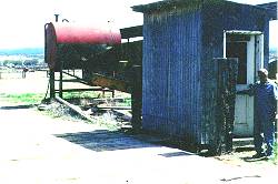
From Highway 319 go north about ¾ miles on Highway 93. After you pass the last house on the East side of the road, turn right on the first dirt road immediately after the house, and go East about 200 yards until you see a bunch of hay sheds and a corral. The weighing shack and scales are straight ahead, adjacent to the road. Alternatively, you can get there from 319. In that case, Westbound from Panaca, turn right a couple hundred yards before 93 on the last dirt road running parallel to that highway (which runs between Pioche and Caliente), and follow it north about ¾ mile. As the dirt road bends to the West, stay on it another couple hundred yards and you’ll see the weighing shack and scales on your left.
How to Weigh:
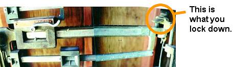
Please obtain separate weights for the steering, drivers, and rear axles of your trailer and then total them. Bring the written figures with you to the mine. The scales are not the last word in digitized technology. You will need to play with the weights a little. There is no electric light inside the shed, so reading glasses are recommended if you are over 40. Be sure to lock the scales in between each weighing, and to bolt the door shut as you found it on arrival. Before yet get out of the tractor have a pen and paper handy—just in case!